|
02-05-1960 ***
A disc was seen falling into the sea. This
reference: USOCAT by The Italian Center for UFO Studies (CISU) © 1996 by Marco Bianchini. http://www.cisu.org/ Original reference: “Giornale
d'ltalia” of 2/9/1960 “Notiziario
CISAER” Jan-May 1960 “La
Torre di Babele” inaccurate date of 1963 UFOCAT
PRN – 125642. Ref. ITACAT-Verga Murizo. Seen 200 Meters off shore. Europe
– Italy, Siracusa Capo Passero - Latitude 36-41 N, Longitude
15-09 E ( D-M ) A
UPI report published on the eleventh of February 1960 stated that at noon,
EST, an object (presumed to be a Russian missile, but later denied) was
spotted by U.S. Navy planes in the Russian impact area of the Pacific. The
object went down into the sea. This reference: Invisible Residents, p. 40, ©
1970 by Ivan T. Sanderson Original
reference: UPI, St. Petersburg, Fla. “Times”, 12 February 1960. UFOCAT
PRN – 77302 Pacific
Ocean – No location given. CISU
Case # 017 This
reference: USOCAT by The Italian Center for UFO Studies (CISU) © 1996 by Marco Bianchini. http://www.cisu.org/ Original reference: “La Torre di
Babele” inaccurate date of 1963 UFOCAT
PRN - NONE Olbia - Latitude 40-55 N, Longitude 9-31
E ( D-M ) Two
truck drivers, separately, about twenty-five miles east of Port Angeles,
Washington, on the ninth of March, 1960, informed police that they had watched
a large flaming object "half the size of a barrel" going down in
the Strait of Juan de Fuca. The fiery object, thought to be a plane, was
not found, and no planes were reported missing or down in or near the area. This
reference: Invisible Residents, by Ivan T. Sanderson, p. 40, © 1970 by Ivan
T. Sanderson. Secondary references: Unexplained
Mysteries of the 30th Century by Janet and Colin Bord, pp.
168, © 1989 by Janet and Colin Bord. Original reference: Seattle “Times”, 9 March 1960
|
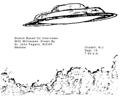 |
As McGuire AFB began an investigation, new reports came
in. On September 21, four Hawthorne police officers watched a device with two
beams like headlights hover over a quarry. Officer George Jediny, in a report
to NICAP, said the UFO -- which he sketched as a disc -- seemed to revolve.
The quarry night watchman, Wm. Stocks, said the UFO had also appeared the
night before. When he drove a Jeep nearer to check up, the object maneuvered
to keep out of the headlights. (Similar reaction often reported. )
Just after midnight, September
24, the same or a similar device was seen over the quarry by over a dozen
Hawthorne police officers and the chief reporter of the N. J. State Press,
George Della Penta. When a police-car spotlight was pointed up at the UFO, it
began to move. Before it left, Mr. Della Penta shot 18 feet of color film.
(Analysis not completed. )
Later, Oradell police received
a letter signed "The Bergenfield Pranksters," purporting to be from
some boys who said they faked the sightings with aluminum-coated model
aircraft supported by helium balloons. This was promptly rejected by the
police and newspapers that checked the facts, among them:
The Newark Evening News,
Science Writer Philip Del Vecchio. "It would have been impossible for
them (the Bergen County boys) to put their model planes so high that they
could be seen in Hawthorne... No object such as they could have put together
could have moved at the lightning speeds attributed to the UFO. The light..,
could not have been produced by amateurs. This newspaper makes an appeal to
other residents ...with the assurance that reports will be treated with
dignity.
The Hawthorne Observer,
rebuking those who accepted an unsigned letter from a town miles away, said
it was time to treat the reports seriously.
The Riverdale Sunday Trend: "Suppose the real hoax is the letter
purporting to explain the whole thing?"
The Hawthorne News Record:
"To imply so flippantly that our police officers spent almost half an
hour looking at a balloon and then watched it speed away at an incredible
rate -- all in quite an opposite direction from Oradell--is insulting."
The Newark Sunday News:
"Flying saucers are still a big mystery...are seen with great regularity
by sane and logical inhabitants of the planet Earth. What they are and where
they come from and what their mission is has not yet been satisfactorily
explained."
Regardless of the final
outcome, these New Jersey sightings have shown that an increasing number of
newspapers no longer accept quick brush-off answers to sightings by competent
witnesses.
This reference: UFO Investigator ( NICAP ), Vol. 11, No. 6,
October/November 1962, pp. 3-4.
Secondary reference:.The APRO
Bulletin, May 1963, pp. 1 & 3.
UFO Investigator, a NICAP publication,
Vol. 4, No. 5 p. 5, (March
1968) with Thanks to the Donald E. Keyhoe Archives.
Passport to Magonia by Jacques Vallee, p.
287-278, 1969
UFOCAT PRN 35885 – Reference NICAP Investigator, November 1962, p.
3
UFOCAT PRN 89693 – Reference APRO Bulletin, May 1963, p. 3 (Letter)
UFOCAT PRN 89692 – Reference APRO Bulletin, May 1963, p. 1 (Letter)
North America – United States, New Jersey
Oradell Latitude
40-78 N, Longitude 74-02 W ( D-M )
Hawthorne Latitude
40-57 N, Longitude 74-09 W
Harrington Park Latitude
40-59 N, Longitude 73-59 W ( APRO Bulletin May ’63 )
Westwood Latitude
40-59 N, Longitude 74-02 W ( APRO Bulletin May ’63 )
San Braen quarry Unable
( from APRO Bulletin May ’63 )
The National Gazetteer of the United
States of America, Prepared by the U.S. Geological Survey in cooperation
with the U.S. Board on Geographic Names, Washington, D.C. 1990.
UFO Location (UFOCAT).. - Latitude 40.96 N, Longitude 74.03 W
( D.% )
12-14-1962
CISU
Case # 020
Location: Intra (NO)
CISU Classification: C ( Objects that come out of the water )
Evaluation: Insufficient information
***
Two Objects surfaced out from a lake and after being still in the sky for 4
minutes disappeared.
This
reference: USOCAT by The Italian Center for UFO Studies (CISU) © 1996 by Marco Bianchini. http://www.cisu.org/
Original reference: “The Paper of
Misteries” no. 22 page 17
“Cielo
e Terra”, year 3, no. 36, April 1972.
UFOCAT PRN - NONE
Europe – Italy, Novara
Intra - Latitude 45-56 N, Longitude 8-34
E ( D-M )
This reference: Italy Gazetteer, United States Board On Geographical
Names, Department of the Interior, Washington D.C., August 1956.
??-??-1963
Sometime in 1963 the
U.S. Navy conducted some exercises to train personnel in the detection
and tracking of underwater craft. The maneuvers were conducted off Puerto
Rico in the Atlantic some five hundred miles southeast of the continental
United States. All reports seem to agree that there were five "small"
naval vessels concerned, but in more than one account the aircraft carrier
Wasp is stated to have been the command ship. There appear also
to have been a number of submarines engaged in these exercises, and
all vessels were intimately linked by advanced electronic communications
systems. There were also aircraft, at least one of which trailed a detection
device a little below the surface of the ocean from a line, while flying
at very low altitude. The submarines are said to have been "fixed"
for what is somewhat mysteriously called "silent running,"
a performance that cries out for further exposition.
There then occurred a rather special and particular uproar which, at least
as far as I have been able to ascertain, was initiated as follows. A
sonar operator on one of the small vessels, otherwise listed as a destroyer,
reported to his bridge that one of the submarines had broken formation
and gone off in what appeared to be pursuit of some unknown object.
This operator did not, of course, know if this was a "plant,"
since the maneuvers they were engaged in were exercises designed to
train personnel in detection of enemy craft, and in such exercises decoys
must of course always be employed. However, this operator's report was
not at all within the limits of any such simulation. Trouble was that
said unidentified subaqueous object was traveling at "over 150
knots"!
The deck officer on watch
immediately reported to the skipper, said to have been a lieutenant
commander, and this officer was not amused. Nonetheless, after calling
his communications boys on the intercom, he got in touch with the command
vessel, the Wasp, but was further frustrated to find that their
radio intake was virtually jammed with similar reports coming in from
all the other ships and from the sonde-trailing aircraft. Then comes
a curious note from more than one of the reports that I have. This is
to the effect that no less than thirteen craft (including submersibles
and aircraft, one must suppose) noted in their official logs that their
underwater tracking devices had latched onto said high-speed submersible.
All of which is said to have immediately been reported to C.O.M.L.A.N.T.
in Norfolk, Va. At this point, all the reports become somewhat vague
and obscure. Various numbers of people, in various numbers of ships,
are alleged to have observed or heard the sonar blips caught by their
own operators, and all to have concurred in the fact that this object
was being driven by a single propeller at more than 150 knots.
The world record for
a propeller-driven surface craft is 200.42 mph, but this was
with a Rolls-Royce-engined hydroplane. The record for a diesel-engined
surface craft is 60.21 mph. The all-time high was achieved by Sir Malcolm
Campbell in his turbojet-engined Bluebird K.7, at 328 mph. The
fastest speeds for submerged submarines have been achieved by the Skip-jack
class of tear-drop-shaped nuclear vessels of the United States Navy.
The semiofficial record is 45 knots (51.8 mph). Thus, the object recorded
above beat anything that we can do at the present stage of our technological
development, by nearly four times in speed.
But that was not the whole
story. It is said that the technicians kept track of this thing/or four
days, and that it maneuvered round about, and down to depths of
27,000 feet. The record dive for a standard submarine is 6,250 feet,
achieved by the U.S. Aluminaut on the 12th of November, 1967,
twenty miles off the west coast of Grand Abaco Island in the Bahamas.
The record for mere submersion is, however, the descent to 35,800 feet
made by the little Trieste in the Pacific in 1960.
However, this craft could hardly move along at all, while the
Skip-jacks cannot go down to more than a sixth of that depth. In other
words, this thing was literally out of our world. What was it? Perhaps
a more pertinent question is, Are these reports true? As I have said,
I have been unable to obtain any confirmation of them. The authors who
originally wrote of them are known and are respectable writers of factual
matters, and they have specialized in underwater investigations, and
apparently with much help and advice from naval authorities. This is
thus, at least as far as I am able to state as of the time of writing,
a dead end. We are then presented with the corollary question as to
how possible and/or probable any such things as the item
described above might be. Here we enter a really extraordinary world
that, except in a very few abstruse quarters, has not up till now been
brought to the attention of the general public. First, it transpires
that this is by no means a unique case. Not only do the authors identified
above constantly state that there have been numerous other reports of
a similar nature by and to our Navy since that date, but that still
others have been reported by several other navies. Second, there have
been equally surprising reports made by both naval and commercial ship's
officers, mostly giving names and dates, and going back more than a
hundred years. Moreover, of those incidents which have occurred since
this classic, several are outstanding and are very properly documented.
This Reference: Invisible Residents by Ivan T. Sanderson, pp. 20-23,
published 1970
Original Reference: “Hydrospace”, New York:EP Dutton, 1964;
Secondary reference:
Ed Hyde, “UFOs-at 450 fathoms!”, Mans Illustrated, March 1966
UFOCAT PRN – 73270. Location –
none
Atlantic Ocean
Location
as given in the text “some five hundred miles southeast of the continental
United States” (Florida) would place the ships more in the area of Cuba
and Haiti, than Puerto Rico.
02-??-1963
In late February
I963, 3-50 miles off tile north coast of Norway in the direction of
Spitsbergen, a very strange radar/sonar event occurred. Ships from the
British Royal Navy North Atlantic Fleet were engaged in exercises, and
on this particular morning, the witness was in charge of the radar-sonar
room on a frigate. A blip denoting a solid object appeared on the radarscope,
and the indications were of an object 100-120 feet across at a height
of 35,000 feet. It appeared suddenly, an impossibility for a conventional
aircraft, but the witness said conditions were not favourable for the
anomalous propagation of false targets. It was learned that the same
target was also on the scope of the nearest ship, but outside the witness
could not locate the object through binoculars, nor could he make contact
with it by radio. Jets were sent up to intercept the object, and when
they were 10-15 miles from it, the men in the radar-sonar room saw its
radar blip make a steep angular descent at great speed, crossing all
three radar screens and going below the radar horizon of 750-1000 feet,
all in 2-3 seconds. Following loss of radar contact, an underwater target
was picked up on sonar, indicating an object moving fast at about 10
miles distance, and in the same direction as the radar target had been
moving. The object dropped into deeper water, moving fast in a zigzag
path away from the ship, and after a few minutes contact was suddenly
lost. The ship steamed to the point where the object had entered
the sea, but nothing was seen and no further contact was made with it.
This reference: Unexplained Mysteries of the 20th Century,
by Janet and Colin Bord, p. 164, Pub. 1989 by Contemporary Book, Inc.
See original text on Radar/Sonar page: Original reference: MUFON UFO
Journal #199 pp. 7-9 by Walter N. Webb
UFOCAT
PRN - None
Europe
- Norway
Spitsbergen is part
of a group of islands, now called Svalbard. The largest island in the
group is western spitsbergen, where I have used the town/city of Longyearbyen
to locate the latitude and longitude as the whole group of islands encompasses
the area between 74 to 81 deg. Latitude and 10 to 35 deg. Longitude.
Longyearbyen, Norway – Latitude
78-00 N, Longitude 16-00 E ( D-M )
http://www.astro.com/cgi-bin/atlw3/aq.cgi?country_list=&expr=longyearbyen&lang=e
03-12-1963
According to the Honolulu
Advertiser of the 13th of March, 1963, residents in Windward
Oahu “observed” a light in the sky north of the island at about 6:30
P.M. yesterday. One resident said it was ‘very bright’ and appeared
to descend slowly into the sea in a series of movements.” It was
reddish and was visible for five or six seconds.
This reference: Invisible Residents by Ivan T. Sanderson, p. 41
© by Ivan T. Sanderson
Original reference: Honolulu
Advertiser, 13 March 1963.
UFOCAT PRN – 73308 (No location)
Central
Pacific Ocean – United States, Hawaiian Islands
The locals’ call the towns of Kailua and Lanikai the “Windward”.
Kailua Latitude 21-24 N, Longitude
157-44 W ( D-M )
Lanikai Latitude 21-23 N, Longitude
157-43 W
Reference: Hawaiian Islands gazetteer, prepared
in the Office of Geography, Department of the Interior, Washington,
D.C., September 1956.
10-??-1963
CISU
Case # 021
Location: San Menáio (FG)
CISU Classification: B ( Objects that fall or dive into water )
Evaluation: Possible Fragment of a satellite
*** An object plunged into the sea and there were a series of fruitless
searches to recover it
This
reference: USOCAT by The Italian Center for UFO Studies (CISU) © 1996 by Marco Bianchini. http://www.cisu.org/
Original reference: “La Torre di
Babele” imprecise date of 1963
UFOCAT
PRN - NONE
Europe – Italy, Foggia
San Menáio - Latitude 41-56 N, Longitude
15-58 E ( D-M )
http://www.astro.com/cgi-bin/atlw3/aq.cgi?country_list=&expr=san+menaio&lang=e
10-31-1963
DISC SUBMERGED IN BRAZILIAN RIVER
On the 31st of October 1963, Rute de Souza, 8-year-old daughter of Elidia
de Souza who live near Iguape, Brazil, heard a strange and increasing
roar and on looking to see where it came from, was terrified to observe
a silvery object coming toward the river near her house, The object
soared over her house, then above her, struck a palm tree near the top
and began to "writhe" and struggle in the air above the river
Then it fell into the Peropava River near the opposite shore.
Rute began to run to her
house to tell her Mother, and met her Mother coming out. Mrs. de Douza
had also heard the roar and ran to investigate. Shortly Raul de Souza,
Rute's uncle, came upon the scene. He, too, had heard the roar where
he was working about 300 feet from the house, All three stood
in amazement as they watched the water "boil up" in the spot
where the disc had fallen. The water continued to surge up, followed
by an eruption of muddy water and then mud.
On the opposite shore
of the river fishermen including Japanese Tetsuo Ioshigawa had witnessed
the event and it was from Ioshigawa that investigators and
reporters obtained sufficient description that led to the estimation
of size of the object--about 25 feet in diameter. All described the
disc as like polished aluminum and shaped like a "wash basin."
The object appeared to be at about 20 feet altitude when it hit the
tree. It was in level flight until that time and after it
struck it began its gyrations which led to the conclusion of the witnesses
that it was experiencing trouble of some sort.
During the ensuing weeks,
divers of various sorts began to attempt a salvage operation. At first,
divers using only face masks tried but failed, to be followed by Scuba
divers and eventually a professional deep sea diver with full diving
suit and air compressor came to attempt to locate the disc. At last
report, nothing had been found and all the divers complained of the
hampering effect of the mud at the bottom of the river. The Peropava
is 12 feet deep at the point where the disc sank and has a muddy bottom
comprised of about 15 feet of mud and clay. If the disc sank through
the water and in turn the mud as the boiling up of water and then mud
seem to indicate, it may have proceeded through the muddy river bed
to solid rock underneath.
In order to fully assess
the meaning of this incident which is pretty well established as having
occurred, we must take into consideration all of the factors. Although
mine detectors were used and the Brazilian equivalent of the Civil Engineers
attempted finding and salvaging the disc, reports do not indicate any
success of any kind, not even the location of the disc.
We must consider the possibility
that the disc, after settling to the bottom, either proceeded through
locomotion of some sort away from its initial resting place and is not
now in the original spot. If so, it could be anywhere in that river.
Also, the size indicates that it may have been manned and if so perhaps
repairs could be affected under water and escape from the river and
the mud accomplished during the night hours, at some spot more isolated
than where it originally sank.
UFOs of various types
have been seen going into and coming out of the water so we must not
assume that this particular disc is necessarily trapped even though
it is a tempting assumption to make. Time will tell and it may be that
the disc will be pulled out of the river eventually. It may be, too,
that other UFOs have already come to the disc's aid and have either
destroyed or salvaged it
The only similar incident
We have logged in APRO files is the incident which took place off the
coast of Venezuela on the 13th of December 1956. A Swedish ship wired
the harbor control at La Guaira saying that a strange, cone-shaped object
was falling vertically into the sea, that it was very brilliant and
gave off "strange glares." The time was 9:50 p. m. and the
object was seen by the Captain and several of the crew. When the object
hit the water an explosion was heard, then the sea where the object
fell became brilliantly colored. After the colors subsided the sea became
very disturbed with a "boiling motion," which continued for
some time.
It is not known whether
or not the object was in trouble in this incident but there is a similarity
between the foregoing sighting and the disc which fell into the Peropava
River.
This reference: THE A.P.R.O. BULLETIN, January 1964, p.2
Secondary references: Piece
for a Jig-Saw, by Leonard G. Cramp, p. 130, 1966, England
Flying
Saucers-Serious Business by Frank Edwards, 1966
Note: wrong date – 10-31-1958.
Passport to Magonia, by Jacques Vallee , p. 295, published
1969.
Invisible Residents, by Ivan T. Sanderson, pp. 74-76, pub.
1970
Official UFO Magazine, May 1977, p41
Unexplained Mysteries of the 20th
Century, by J & C Bord, p. 171,
published 1989
UFOCAT PRN – 87690, Ref. Piece for a Jig-Saw, by Leonard G. Cramp.
No location
South America - Brazil
Peropava River.Latitude 24.39
S, Longitude 47.31 W
Iguape Latitude 24.43
S, Longitude 47.33 W
Reference: Brazil Gazetteer, Prepared in the Office of Geography, Department
of the Interior, Washington, D.C., January 1963
11-20-1963 (Wednesday was the 20th)
Mystery at sea
We are indebted to Mr. Harry Lord for having sent us the
following cutting from the “Northern Echo”, dated November 22, 1963:
"The Aberdeen collier Thrift arrived in Blyth at noon
yesterday eight hours overdue after an unsuccessful search off Girdleness for
a mystery object, which disappeared into the sea three miles astern of the
ship. The Thrift was heading south for Blyth when shortly before 6 p.m. on Wednesday evening
four members of her crew including the skipper, Capt. J. Murray, saw a
'flashing red light' which passed within a mile of her port side, 15 to 30
ft. above sea level, and suddenly disappeared three miles astern.
"Capt. Murray alerted Stonehaven
radio, put his vessel about and made for the spot where the light had
vanished. The collier had two radar contacts on her screens, but when she
reached within a quarter of a mile of them, they disappeared.
The Thrift searched for three hours, circling the area several times and was
joined by lifeboats from Aberdeen and Gourdon, a Shackleton from RAF Kinloss.
which dropped flares on to the surface, and a B.P. transporter. They
discovered no traces of wreckage, however.
"The Thrift gave up the
search at 8.50 p.m. and went to Blyth, being further delayed because of bad
weather.
‘We could not make out what the
light was.' said Capt. Murray. It passed about three quarters of a mile off
our port side, flashing brilliantly until it disappeared. It made no noise at
all, yet we could hear the Shackleton when it was miles away. Judging by the
way the radar contacts disappeared from our screen it seems that whatever was
there must have sunk before we could get to it. We found no trace of wreckage
during our search, but something definitely fell into the water.' "
This reference: Flying Saucer Review, Vol. 10, No. 2, p. 22, March/April
1964.
Secondary references: Invisible
Residents, by Ivan T. Sanderson, pp. 41-42, © 1970
Flying Saucer Review, Vol. 17, No. 5
Sept./Oct. 1971, pp. 29-30
Original reference: “Northern Echo”, dated November 22, 1963
UFOCAT PRN – 87088. Location - none
Europe – United Kingdom
Girdle_ness Latitude 57-08 N, Longitude 2-03 W ( D-M ) [ Cape ]
Blyth Latitude 55-07 N, Longitude 1-30 W
Reference: United Kingdom Gazetteer, Prepared
in the Division of Geography, Department of the Interior, Washington,
D.C., April 1950
12-02-1963
Lake Searched for Object
Three Coast Guard boats scoured
Lake Erie waters near Dunkirk, New York on the 3rd of December, 1963,
in search of what several observers reported was a glowing object which
passed through the sky and then plunged into the lake on the night of
2 December. Some observers felt the object looked like an airplane explosion,
others thought it looked like a meteor. There were no reports of missing
planes or distress calls from same, and the Coast Guard, after completing
their search, announced that they had not sighted any plane or unusual
object in the water.
This reference: The A.P.R.O. Bulletin, September 1964, p. 6
Secondary reference: Invisible
Residents by Ivan T. Sanderson, published 1970., p226
UFOCAT PRN – 76785
North America – United States, New York
Dunkirk – Latitude 42-29 N, Longitude 79-20 W ( D-M )
Reference: The National Gazetteer of the United States of America,
Prepared by the U.S. Geological Survey in cooperation with the U.S.
Board on Geographic Names, Washington, D.C. 1990
UFO Location (UFOCAT) –
Latitude 42.48 N, Longitude 79.30 W ( D.% )
01-09-1964
CISU
Case # 022
Location: Sant'Eufemia Lamezia (CZ)
CISU Classification: D ( Objects on the waters surface )
Evaluation: Possible ROV
*** Some people saw an object on the surface of water and after touching it
with a oar received an electric shock.
This
reference: USOCAT by The Italian Center for UFO Studies (CISU) © 1996 by Marco Bianchini. http://www.cisu.org/
Original reference: “Rome” of 1/12/1964
“ItaCat”
case no. 6402
“II
Messaggero” of 1/10/1964
“II
Secolo” of 1/10/1964
“II
Mattino” of 1/18/1964
AAW “UFO in Italy”, vol. 3, ed. Upiar, pp.
120-121
A. Perego "The extraterresrtian have
come back”, ed. CISAER, p. 43-44
R. Pinotti “UFO: Scacchiere Italia” ed.
Oscar Mondadori, p. 100
“II
Mattino dei Giovani” of 12/12/1984
“Il
Giornale d'Italia of 6/10-11/1965
“Clypeus”
no. 1 of January 1965
UFOCAT PRN – 107007. Ref. Flying Saucer, January 1966, p. 62 by Roberto
Pinotti
Sighting
dated as 01-EE-1964.
Europe
– Italy, Catanzaro
Sant'Eufemia Lamezia - Latitude
38-55 N, Longitude 16-15 E ( D-M )
This reference: Italy Gazetteer, United States Board On Geographical
Names, Department of the Interior, Washington D.C., August 1956.
01-23-1964
THE “FIRST” OFFICIAL “UNKNOWN” – THE ELECTROMATIC
LIGHT WHEEL NEAR GROOTE EYLANDT
According to the summary we have to wait until January 23rd,
1964, for the first official “unknown” in the RAAF Directorate of Air
force Intelligence (DAFI) files. For a list of “Aerial sightings” it
is unusual for it was reported as located in water. The summary describes
the report as follows:
“Seen at sea by crew of a
vessel NE Point of Groote Eylandt, WA.
Large lights in water, made compass go ‘Haywire’. Shadow in center of
lights rotated clockwise, causing lights to pulsate.”
Biologist, Ivan T. Sanderson,
lists it in his book Invisible Residents – A Disquisition upon Certain
Matters Maritime, and Possibility of Intelligent Life under the Waters of
this Earth in a listing of submarine ”Lightwheels“. Sanderson sourced his
brief listing from a newspaper article.
The Air Force Intelligence
files hold a report of the unusual sighting made by the crew of the landing
craft Loellen M. The incident was located between Cape Grey and the
northeast point of Groote Eylandt, a large island on the western side of the
Gulf of Carpentaria, Northern Territory. The official summary incorrectly
lists the incident as occurring in ‘WA” (Western Australia). The report
mentions that the vessel encountered a number of submarine “light patches”:
C. W____ turned on the compass
light and found the vessel approx 60°off course. The compass went ‘ Haywire
‘.
As soon as he had corrected
the vessel as best he could, he switched off the compass light and found the
un-natural light was about 6ft. on the Starboard side. The light was in the
water. It was described as a ghostly white light, in the center was a shadow
which rotated in a clockwise direction causing the light to pulsate. The
light appeared to draw away to the stern. It is estimated that it was miles
across and a few hundred yards through…
“The light on the water passed
about 100 yds to port. As the barge began to return to course, another light
was seen coming at the barge at an angle of about 45° which [sic? – with?]
the Bow. It came to within inches of the starboard side and appeared to
rebound at 45° with the stern and moved away. It disappeared in a
few seconds …”
“All lights were the same
colour, with this strange rotating shadow, causing the lights to pulsate. The
pulsations timed at 12 for 9 seconds, then completely irregular, then settled
down to 12 for 9 seconds.
“The compass swung out of
control, but became worse as the light approached …
This is a fascinating report
but its origins may lie in some form of extraordinary bioluminescence.
This reference courtesy of UFO researcher Bill Chalker of Australia and
his contribution to web site: http://www.project1947.com/forum/bcoz5.htm#groote
Secondary reference: Invisible
Residents by Ivan T. Sanderson, p. 112, © 1970 by Ivan
T. Sanderson, whose original reference
was “Some Australian
Sightings” (taken from Department of
Air files), bylined by John
Hallows, in an unidentified Australian
newspaper (probably
Victoria).
UFOs Over the Southern Hemisphere, by Michael Harvey, p.
204, 1975
* The
paper in question is “The Australian” of May 15, 1968., as relayed to
me in an e-mail by Bill Chalker.
UFOCAT PRN – 81400 (Sanderson) No Location
UFOCAT PRN –135236 (Harvey) No Location
Australia - Western Australia
Groote Eylandt Latitude 14-00 S, Longitude 136-40
E ( D-M ) [Island]
Cape Grey Latitude
13-00 S, Longitude 136-40 E
Gulf of Carpentaria Latitude
14-00 S, Longitude 139-00 E
Reference: Australia Gazetteer, Prepared in the Office of Geography,
Department of the Interior, Washington, D.C., June 1957
04-13-1964
ENGLAND
Walthamstow "object from space"
The “Walthamstow Guardian” reported
a most unusual incident in its April 17 issue: "An unidentified flying
object hurtled through the air above Walthamstow, scythed down telephone
wires, etched a deep scar in the concrete edge of the River Lea towpath and
plunged into the peaceful waters.
"That was the report received by
police just before nine o'clock on Monday night (April 13). It came from
Walthamstow bus driver Bob Fall, a down-to-earth man of 26, who lives with
his wife and two children at 47, Upper Walthamstow Road.
"A police search party went
straight to the spot, just off Ferry Lane. They found the phone wires down
but a search of the banks revealed nothing. The river was dragged--in vain.
"And this week Bob Fall told
‘The Guardian” what happened as he drove his 123 bus towards Tottenham
on Monday. He said, 'I just glanced into the sky and saw something coming
towards me very, very fast. It flew straight across the road and, had I been
a few yards further forward, it would have hit the top deck of the bus. I saw
it cut through the telephone wires and there was a loud crash as it struck
the bank.
"At first I thought the back windows
of the bus had come in and, as I turned around, I saw all the passengers
looking out towards the river. There was a big splash in the water. I stopped
as soon as I could to report it.
"A police spokesman said that
four ducks had been disturbed while the river was being dragged and that
these, flying in line, could have been the object. He stressed that the river
was only four to six feet deep in this part.
"But Mr. Fall discounted this
theory. 'The thing was at least nine feet long, probably more, cigar-shaped
and silver,' he said, 'If it had been a bird or birds I must have seen the
wings. Besides, it was going too fast'."
This reference: Flying Saucer Review, Vol. 10, No. 4, p. 21, July/August,
1964.
Secondary reference: Invisible residents
by Ivan T. Sanderson, p. 226, 1970
Flying Saucer Review, Vol. 17, No. 5,
pp. 29-30, Sept./Oct. 1971
Original reference: Newspaper
“Walthamstow Guardian”, April 17 issue, 1964
UFOCAT PRN – 74073
Europe – United Kingdom
Walthamstow Latitude 51-36 N,
Longitude 0-02 W ( D-M )
Tottenham Latitude 51-36 N,
Longitude 0-04 W
River Lea Latitude 51-31 N,
Longitude 0-02 W
Reference: United Kingdom Gazetteer,
Prepared in the Division of Geography, Department of the Interior,
Washington, D.C., April 1950
UFO Location
(UFOCAT) - Lat. 51.57 N, Long. 0.02 W ( D.% )
08-20-1964
The
20th of August, 1964: Two boys, Pat and Cliff Irwin of Richland, Washington,
reported to the Coast Guard that a red-and-white plane had crashed in
the sea off Oysterville, leaving a red-and-white smoke trail. The
Coast Guard duly checked but found nothing; no planes were missing?
This reference: Invisible Residents, by Ivan T. Sanderson, p. 42,
© 1970
Original reference: Seattle Post-Intelligencer, 21 August 1964
UFOCAT PRN – 73310
North
America – United States, Washington
Oysterville Latitude
46-33 N, Longitude 124-02 W ( D-M )
http://www.astro.com/cgi-bin/atlw3/aq.cgi?country_list=&expr=oysterville&lang=e
Richland Latitude 48.17 N,
Longitude 119.17 W
Reference: The National Gazetteer of the United States of America, Prepared
by the U.S. Geological Survey in cooperation with the U.S. Board on
Geographic Names, Washington, D.C. 1990
UFO location
( UFOCAT ) - Latitude 46.28 N, Longitude 119.29 W ( D.% )
09-??-1964 ( Included
because of effect on water )
RECENT 1st Person Witness
Report.
9-64: Colonie, N.Y., Albany County
Three boys were target
practicing at a sand pit in Colonie when they noticed a strange light
moving slowly over the tree tops on the hill opposite. The light was
silent and approached slowly until it was within 200 feet and they could
make out a circular object with a bubble top. The edge was rimmed in
lights and another light was at the top of the object. As the object
passed over the water of a small pond, they saw three foot waves erupt
beneath the object. The three boys then ran from the site.
This reference: e-mail received from Larry Clark MUFON-FI, February
26, 2000,
http://www.nymufon.org
Originial Reference: MUFON file.
UFOCAT PRN – None
North
America – United States, New York
Colonie – Latitude 42-43 N, Longitude 73-50 W ( D-M )
Reference: http://www.astro.com/cgi-bin/atlw3/aq.cgi?country_list=&expr=colonie&lang=e
09-20-1964
[Note: Possible date error, 30th,
see references below]
(extract p. 4)
Two months later this same Gulf of San Jorge was the scene
of yet another phenomenon of similar outline. An individual known and
respected for his honesty, who requested that his name not be revealed,
reported that on September 30, 1964, while he was driving at night to the
city of Comodoro Rivadavia coming from Caleta Oliva, he saw appear at the
edge of the city some strange objects (3 or 4) that described parabolas and
descended one after another into the sea. The unusual spectacle caused
the witness to stop his vehicle so as to carefully observe the flames which
the objects were leaving as they passed.
After resuming his journey and
having traveled some distance from the initial point of observation, he
noticed other luminous objects -- or perhaps the same objects -- emerge from
the surface of the water and then circle around at a dizzy speed, and
within an outline of shining light again climb up and finally disappear
into the sky.
This reference: The MUFON Journal, Vol. #130, pp.3-5 September 1978 “Are UFOs
Operating from underwater bases off the coast of Argentina” by Joseph M.
Brill.
Secondary reference:
Unexplained Mysteries of the 20th Century, by Janet and Colin
Bord,
pp.
170-171. Published 1989
Note: Both references above
show the date as the 30th
Original reference: GEPA, Phenomenes Spatiaux #18, p. 12 December 1968.
Sighting date 09-20-1964
UFOCAT
PRN – 76692. Ref.
Phenomenes Spatiaux #18. Note:
Possible typo - Date discrepancy – this reference shows 09-20-1964.
South America - Argentina
Comodoro Rivadavia Latitude 45-52 S, Longitude 67-30 W ( D-M )
Gulf of San Jorge Latitude
46-00 S, Longitude 67-00 W
Caleta Oliva Latitude
46-26 S, Longitude 67-32 W
Reference: Argentina Gazetteer, Prepared
in the Office of Geography, Department of the Interior, Washington, D.C.,
February 1968.
UFO Location (UFOCAT) - Latitude 45.83 S, Longitude
67.50 W ( D.% )
11-??-1964
Witness says UFO came out of water
MUFON investigator Robert D. Neville has submitted the following account
of his interview with Frank S. Kinsey, conducted Nov. 3, 1973:
It... "was about
ten years ago," (Circa 1964) Mr. Kinsey begins. “It was down behind
the hills in Ventura, Ca., where the government put in a new dam up
there." (Casitas Dam.) "It was a drizzly day--cloudy."
He estimated the time of day as 11 a.m. “My brother-in-law took me up
there. We were standing there, chatting for about ten or fifteen minutes
and then, all of a sudden, I heard sort of a loud noise and water splashing,
and I looked out into the lake and here's this object coming out of
the water.
"I was so flabbergasted...
I was speechless to think I could see something like that which I've
never seen before...And it was a round object and it looked like it
had a cone on top, where a person was looking out at us. I had a camera
around my neck, but I completely forgot the camera due to the fact that
I was so astounded to see something like this coming up out of the water.
It came out of the water, I'd say about twenty or thirty feet, and hovered
… By that time, my brother-in-law and I got to talking and .., I happened
to remember that I had my camera...and just as I was getting the camera
up to my eyes, this object started moving away, and I just barely got
it near the edge of the film; then, within a few seconds it disappeared
out over the mountains…I'd say about
ten or fifteen miles away.
“...As it was speeding
up, it started changing colors, from a real dark lavender color up to
a real bright orange-yellow, and that's the last I saw of it.”
Describing the object
in more detail, Mr. Kinsey added that the main body was cylindrical
in shape, drum like, with the "observation cone on top" in
which he saw windows or portholes. Mr. Kinsey noted that the object
appeared to be about 20 or 30 feet in height, and that inside it "looked
like a being looking out at us," a humanoid form.
"I could see the eyes staring at us. I happened to have
a pair of binoculars with me at the time. I picked them up and looked
and could see a person looking out at me.
"It looked like it
was a real thick heavy glass of some kind, or maybe it might have been
a plastic of some kind--you know, never seeing anything like that before.”
Mr. Kinsey noted that the object or a portion of the object appeared
to be rotating rapidly upon its axis. "What was moving on the object
was the outside cylinder. It was turning around at a very high rate
of speed...It made an awful loud noise like a jet taking off. The faster
it turned, the louder the noise got…it was awful to the ears.
"The center part
up on top that looked like (it had) portholes to it, that was absolutely
still. The faster it turned (the more) it changed color, as though it
were transparent and lights were going through it.
"When it came up
out of the water, it was like a funnel sucking up water. It brought
the water up with it due to the fact that it was whirling so fast.
"...It looked to
me as though it were well insulated and well made...It had a gleam to
it, it had a shine to it, like nothing I've ever seen. I've seen a lot
of metals here on earth that had a high gloss, but nothing like this
that I've ever seen.”
"I've kept my mouth
shut all these years due the fact that people ridicule people..."
It should be noted that Mr. Kinsey was an Air Force pilot during World
War II. He is a very respected member of the community and a very outspoken
and direct individual. In this investigator's opinion, Mr. Kinsey's
familiarity with conventional aircraft and his unquestioned honesty
and sincerity provide this report with a high degree of credibility
in spite of its very unusual content.
The only other known witness
to the sighting (Mr. Kinsey's brother-in-law) is now deceased.
The above photo was taken of a UFO (object in upper left)
after the object came out of the water near Casitas Dam according to the
witness and photographer, Frank S. Kinsey. The photo which was taken about
ten years ago and revealed only recently, was reportedly taken on infrared
film using a Super D Topcon 35mm camera with a 33mm 2.8 wide angle lens set
at f/8. The shutter was set at 1/25. This photo is currently being analyzed
by MUFON consultant Adrian Vance for authenticity. Results of this
analysis will be published when received.
This Reference: Skylook (The original MUFON Journal), September 1974. p.
8
Secondary reference:
Unexplained Mysteries of the 20th Century, by Janet and Colin
Bord, pp. 176-7, published 1989. NOTE: Date (November) taken from this
reference, although the only allusion to November is the interview date.
UFOCAT PRN – NONE (probably due to a lack of a specific
date.)
North
America – United States, California
Ventura Latitude 34-17
N, Longitude 119-18 W ( D-M )
Casitas Dam Latitude 34-22 N,
Longitude 119-20 W
Reference: The National Gazetteer of the United States of America, Prepared
by the U.S. Geological Survey in cooperation with the U.S. Board on
Geographic Names, Washington, D.C. 1990
Construction of Casitas Dam began in July 1956 and was completed in
March 1959.
Reference : http://dataweb.usbr.gov/dams/ca10139.htm
??-??-1965
CISU
Case # 024
Location: Cattòlica (RN)
CISU Classification: C ( Objects that come out of the water )
Evaluation: Insufficient Information
*** Five objects disc shaped have been seen emerging from the sea and going
away with an inclination of 45 degrees.
This
reference: USOCAT by The Italian Center for UFO Studies (CISU) © 1996 by Marco Bianchini. http://www.cisu.org/
Original reference: R. Pinotti “UFO: Missiona Uomo (mission
man)” ed. Armenia, p.137
R. Pinotti "UFO: scacchiere
Italia" ed. Oscar Mondadori, page 101
“ItaCat”
case no. 6501.
UFOCAT
PRN – Possibly 125660 – ITACAT by Verga Maurizio dated as 08-??-1965
Europe
– Italy, Rimini
Cattòlica - Latitude 43-58 N, Longitude 12-44
E ( D-M )
This reference: Italy Gazetteer, United States Board On Geographical
Names, Department of the Interior, Washington D.C., August 1956.
01-11-1965
The
Seaside (Oregon) Signal on the 12th of January, 1965,
noted that Mrs. Paul Zimmerman Gearhart and her two sons saw a triangular
UAO which came slowly out of the southeast an then “suddenly plunged
into the sea some miles off shore" at Tillamook Head. It
left two trails of fire behind.
This reference: Invisible Residents by Ivan T. Sanderson, p. 42,
Pub. 1970
Original reference:
The Seaside (Oregon) Signal, 12th of January, 1965
UFOCAT PRN – 73312
North America – United States, Oregon
Tillamook Head -
Latitude 45-56-47 N, Longitude 123-59-30 W ( D-M-S )
Reference: The National Gazetteer of the United States of America,
Prepared by the U.S. Geological Survey in cooperation with the U.S. Board on
Geographic Names, Washington, D.C. 1990
UFO Location (UFOCAT) - Latitude 45.44 N, Longitude
123.85 W ( D.% )
01-12-1965
USO in Kaipara Harbour (New Zealand)
On January 12, 1965, Captain K., an airline pilot, carried out a “positioning”
flight (no passengers) from Whenuapai (Auckland's airport) to Kaitaia
(north of Auckland). The crew comprised Captain K., first officer and
operations officer. They left Whenuapai at 11 a.m., and were to reach
Kaitaia by 12.10 p.m. Captain K. decided to fly visually, following
the coast line at low altitude. On approaching the southern end of Kaipara
Harbour (just north of Helensville) he dropped 500 feet to have a closer
look at anything on his flight path. The plane was a DC3. The tide in
the harbour was well out and the water over the estuaries and mudflats
quite shallow. When about one third of the way across the harbour, he
spotted in an estuary what, at first glance, he took to be a stranded
grey-white whale. He veered the aircraft slightly to port in order to
fly more directly over the object, and on approaching it, he saw that
what he had mistaken for a whale was a metallic structure of some sort.
He observed the following details:
1. It was perfectly streamlined and symmetrical
in shape.
2. It had no external control surfaces or protrusions.
3. It appeared metallic and there was a suggestion of a hatch on top,
streamlined in shape, not quite halfway along the body as measured from
the nose.
4. It was resting on the bottom of the estuary and headed towards the
south as suggested by the streamlined shape.
5. The shape was not that of a normal submarine.
6. Captain K. estimated its length at 100 feet, with a diameter of 15
feet at the widest part.
7. The object rested in no more than 30 feet of water and the craft
was very clearly defined. Captain K. did not alert the other two crew
members, having been ridiculed over the years for various other reports.
However, in May he reported to Navy Intelligence, who confirmed that
due to inaccessibility of the estuaries, the craft sighted could not
possibly have been a conventional submarine. Although the Navy may
have checked the spot, we are unaware of it.
This reference: Flying Saucer Review, July/August 1966, vol. 12,
no. 4, pp. 28-29
Submarine Craft in Australasian Waters by H. J.
Hinfelaar
Secondary reference:
Unexplained Mysteries of the 20th Century, by Janet & Colin
Bord,
p. 168, published
1989.
Original
reference: Spaceview No. 43
01-29-1965
On the 29th of January, in Monterey, Calif., Mayor George
Clemens and his family spotted a very bright light performing "aerobatics"
in the northern sky. It hovered a while, then shot straight up at high
speed for about five hundred feet, then faded and dropped down and hovered
again. Then it dropped further down toward the water and disappeared.
This was also seen by a local flyer in the air at the time. The
Coast Guard investigated but found nothing and had no explanation.
This reference: Invisible Residents by Ivan T. Sanderson, pp. 42-43,
Pub. 1970
Original Reference: Monterey Peninsula Herald, 30 January 1965
UFOCAT PRN – 73313
North America – United States, California
Monterey – Latitude 36-36-01 N, Longitude 121-53-37
W ( D-M-S )
Reference: The National Gazetteer of the United States of America,
Prepared by the U.S. Geological Survey in cooperation with the U.S.
Board on Geographic Names, Washington, D.C. 1990
UFO Location
(UFOCAT) - Latitude 36.60 N, Longitude
121.90 W ( D.% )
02-12-1965
(Extract)
UFOs AHOY! by Janet Gregory
Only a few days afterwards,
a "ghost plane" was seen to dive into the sea near Minehead
on the North Devon coast. On February 12, 1965, four witnesses saw the
object from two different points along the coast. A lifeboat, two RAF
helicopters and a Shackleton failed to find anything after a search
of an hour and a half, and no planes were reported missing. The "ghost
plane" may have been seen inland before it reached the sea, for
a strange low-flying plane was reportedly seen over Swainswick, near
Bath in Somerset. The sighting of the plane, ash-grey and flying about
one hundred feet above the road in a west to south-west direction, was
described by the witness as follows. "The plane was so unusual
that it attracted our attention. There was definitely something abnormal
about it. It did not seem to be distinct, but had a misty appearance,
yet there was no mist or fog about. It came from behind some trees.
Then it literally just disappeared before our eyes. The strange part
was that it made no sound, and did not appear to have an engine.
But it was certainly not a glider." Shades of John Keel ?
This Reference: Flying Saucer Review Vol. 17, No. 5 September/October
1971 pp. 29/30
Original: Flying Saucer Review, Vol. 16, Nos. 3 &4 “Mystery aeroplanes
of the 1930s” by John Keel, and Vol. 17, No. 4
UFOCAT PRN – 74076
Europe - United Kingdom
Minehead Latitude 51-12 N, Longitude 3-29
W ( D-M )
[The “Sea” would be the “Bristol Channel and Bridgwater
Bay]
Devon Latitude 50-45 N, Longitude 3-44
W
Swainswick Latitude
51-24 N, Longitude 2-21 W
Bath Latitude 51-23 N, Longitude 2-21
W
Somerset Latitude 51-05 N, Longitude 3-00
W
Reference: United Kingdom Gazetteer, Prepared in the Division of Geography,
Department of the Interior, Washington, D.C., April 1950
UFO Location (UFOCAT) Latitude 51.22
N, Longitude 3.48 W ( D.% )
04-11-1965
The Wonthaggi (Australia) USOs
On April 11, 1965, two men had gone to the beach at Wonthaggi, 82 miles
from Melbourne, to inspect a wrecked fishing boat. While on the cliffs
they saw two objects about half a mile off shore and watched them for
15 minutes. One of the men, Mr. R. Banks, said, "We saw two strange
craft, half a mile off shore and about 100 yards apart. Their strange
appearance had us baffled, so we sat down and watched them. They turned
away from one another and headed out to sea. While they were going away
they disappeared, and then we realized they were submarines and only
their conning-towers had been showing ". The sighting was reported
to the Navy and a naval spokesman commented as follows: -“A preliminary
investigation of the report suggests, in view of the locality and configuration
of the coastline, that the objects are unlikely to have been submarines.
"--It was also stated that the objects could not have been either
British or American submarines, as 'the Royal Navy submarines operating
in Australia were in Sydney, and that any movements of American craft
in or near Australian waters were generally reported to the, Royal
Australian Navy.
This reference: Flying Saucer Review, July/August 1966, vol. 12,
no. 4, p. 29 Submarine Craft in Australasian Waters by H. J. Hinfelaar
.
Secondary references:
Unexplained Mysteries of the 20th Century, by Janet &
Colin Bord,
p. 167-168.
Original reference: Spaceview No. 43
UFOCAT PRN – 87234
Australia - Victoria
Wonthaggi Latitude 38-37
S, Longitude 145-32 E ( D-M )
Melbourne Latitude 37-50 S,
Longitude 145-00 E
Reference: Australia Gazetteer, Prepared in the Office of Geography, Department
of the Interior, Washington, D.C., June 1957
UFO Location
(UFOCAT) Latitude 38.63 S, Longitude 145.62 E ( D.% )
04-15-1965
(extract)
Three Sightings North of Brisbane
Three sightings of a submarine north of Brisbane, Queensland, were reported
over a period of 5 days.
On April 15, 1965, two youths
reported seeing a cylindrical or oval-shaped object three-quarters of a mile
off Coolum. All reported sightings were investigated by an expert submariner from
Sydney, but no comments have been made.
This reference: Flying Saucer Review, July/August 1966, vol. 12,
no. 4, p. 29
Submarine Craft in Australasian Waters by H. J. Hinfelaar
Original reference: Spaceview No. 43
UFOCAT PRN – 87235 (No location)
Australia
- Queensland
Brisbane Latitude 27-30
S, Longitude 153-01 E ( D-M )
Coolum Latitude 26-33
S, Longitude 153-05 E
Reference: Australia Gazetteer, Prepared in the Office of Geography,
Department of the Interior, Washington, D.C., June 1957
04-18-1965
(extract)
Three Sightings North of Brisbane
Three sightings of a submarine north of Brisbane, Queensland, were reported
over a period of 5 days.
On Sunday night, April 18,
1965, two fishermen were chased by a big vessel off Mooloolaba, near
Brisbane. They said the craft was 100 feet long, had a small bridge and had a
cabin or cowling on its stern. All reported sightings were investigated by an
expert submariner from Sydney, but no comments have been made.
This reference: Flying Saucer Review, July/August 1966, vol. 12, no. 4, p.
29
Submarine Craft in Australasian Waters by H. J. Hinfelaar
Original reference: Spaceview No. 43
UFOCAT PRN – 87236 (No location)
Australia
- Queensland
Mooloolaba Latitude
26-41 S, Longitude 157-03 E ( D-M )
Brisbane Latitude 27-30
S, Longitude 153-01 E
Reference: Australia Gazetteer, Prepared in the Office of Geography,
Department of the Interior, Washington, D.C., June 1957
06-??-1965
CISU
Case # 023
Location: Sant'Eufemia Lamezia (CZ)
CISU Classification: D ( Objects on the waters surface )
Evaluation: Insufficient information
***
Objects that emenated blue lightning; perhaps we deal with the same case no.
022.
This
reference: USOCAT by The Italian Center for UFO Studies (CISU) © 1996 by Marco Bianchini. http://www.cisu.org/
Original reference: “Il Giornale
d'ltalia” of 6/10-11/1965
UFOCAT
PRN - NONE
Europe – Italy, Catanzaro
Sant'Eufemia Lamezia - Latitude
38-55 N, Longitude 16-15 E ( D-M )
This reference: Italy Gazetteer, United States Board On Geographical
Names, Department of the Interior, Washington D.C., August 1956.
06-06-1965
The Fraser Island (Australia) incident
On
June 6, 1965 private aircraft pilot, Mr. C. Adams, and a television
cameraman Mr. Les Hendy, reported seeing four or five “mysterious objects”
floating in the sea 3 miles east of Fraser Island, 150 miles north
of Brisbane, at about 11.30 a.m. Mr. Adams first noticed two of the
objects from a distance of about 8 miles while flying over Fraser Island.
The weather was clear and the objects appeared to resemble two big dark-coloured
logs. They were narrow and up to 100 feet long. As he steered
toward them two or three similar but smaller objects appeared near the
other two. They did not appear to move, but seemed to “sort of submerge"
when the plane was about one mile away from them. From the air they
appeared to be lying just below the surface and when “submerging” from
sight seemed to do so without disturbing the surface. Mr. Adams was
certain that the objects were too big to be fish or sharks, and the
wrong shape to be whales. Mr. Hendy regretted that they were too far
away from him to film them. Several experts got their heads together
and decided that the objects sighted were migrating whales. However,
their explanation was soon squashed when part-owner of the Seabrae Hotel--Mr.
G. Sampson--and Mrs. V. Grady reported that they had sighted a similar
object on the very same day, half-a-mile out between Redcliffe Pier
and Redcliffe Point. They watched it for 10 minutes. It was long and
black and there appeared to be a black balloon suspended over it. A
Fisheries Dept. spokesman commented that it was unlikely to be a whale,
because they very seldom come into Morton Bay.
This reference: Flying Saucer Review Vol. 12, No. 4, p. 29 July/August
1966, “Submarine Craft in Australian
Waters”, by H.J. Hinfelaar
Secondary references:
Unexplained mysteries of the 20th Century, by Janet &
Colin Bord,
p. 168, published 1989..
Original reference: Spaceview #44
UFOCAT PRN 87238 (Location – None )
Australia
- Queensland
Fraser Island 3 listings, closest
to the other points mentioned being:
Latitude 25-15 S, Longitude 153-10 E ( D-M )
Redcliffe Point Latitude 27-14
S, Longitude 153-07 E
Moreton Bay Latitude 27-15 S,
Longitude 153-15 E
Brisbane Latitude 27-30
S, Longitude 153-01 E
Redcliffe Pier No listing in
the gazetteer.
Morton Bay I believe is a
spelling error. There is a Morton, but only as a city, NO Bay (See Moreton
Bay, above )
Reference: Australia Gazetteer, Prepared in the Office of Geography,
Department of the Interior, Washington, D.C., June 1957
06-21-1965
1965 Report Listings ( Extraction )
For the benefit of members who are doing statistical studies, we
include here a brief description of 1965 reports not given space elsewhere
in the Bulletin. They are arranged chronologically
and all are considered to be good UAO cases.
21 June. East of Traser
Isand off Maryborough, Australia. Long,
slender metallic appearing object seen submerged just under surface
of water by pilot, 11:30 a. m. As plane approached object submerged
out of sight.
This reference: The A.P.R.O. Bulletin, January-February 1966, p.
8
With thanks to Larry Hatch’s *U*
UFO Database, see http://www.larryhatch.net
UFOCAT PRN – NONE
Australia
- Queensland
Note: There are two Maryborough’s in Australia. One is inland and not
opposite any island. The other is opposite “Fraser” island not Traser
island.
Maryborough Latitude 25-32 S,
Longitude 152-42 E ( D-M )
Fraser Island Latitude 25-31
S, Longitude 153-8 E
Reference: Australia Gazetteer, Prepared in the Office of Geography,
Department of the Interior, Washington, D.C., June 1957
07-06-1965
‘CIGAR’ PASSES A FEW HUNDRED
FEET ABOVE NORWEGIAN SHIP
Gordon Creighton has
translated from the Norwegian newspaper Moss Dagbled of
December 27,1965. the following remarkable account of another
sighting which took place not many miles S.W. of the Azores three days
before and may relate to the self-same UFO.
Chief Mate Torgrim Lien of the T.T. Jawesta, owned by the
Jahr "Shipping Company, had a curious experience while his ship
was en route last summer from Puerto La Cruz, Venezuela, to the Canary
Islands. Lien saw a so-called ‘flying saucer' only 200.4. metres above
the ship. The incident took place in the North Atlantic on July 6, and
a report on it was sent to various authorities; including the Geophysical
Institute in Bergen. This report has never been published in any newspaper
until now... The report is considered to be a very good one.
THE REPORT
(from Ship's Log)
T.T. Jawesta. North Atlantic. July 8, 1965. Report Regarding
Unidentified Flying Object. On Tuesday July 6 1965, while en route
from Puerto La Cruz, Venezuela, to Santa Cruz de Tenerife in the
Canary Islands. at 2152 hours GMT, the ship's position being 24° 40’
N 31°15’ W, with wind from N.E,, strength 5, Low cloud ceiling traveling
with the wind. Barometer 1023. Temperature 23° Celsius.
"At 2152 GMT
(1852 ship's time), the look-out on the port side of the bridge reported
a bright object in the sky moving in a northerly direction. When
I got around to the port side I saw an intense blue fiery tongue which
was approaching the ship at tremendous speed. I ran to the telephone
and rang the captain and without waiting for an answer I seized binoculars
and ran out on to the starboard side and saw the object through the
binoculars as it passed over the ship. It passed straight abaft of the
ship and at a height of from 200 to 400 metres, under the low clouds.
"It was bright like a star, and the moonlight was shining through
between the low clouds and I could clearly see the outlines of the upper
part of it. Its shape was that of a cigar, and I could clearly see a
row of square windows and the faint golden-orange coloured light
from inside it. There was no sign of
wings or rudder. The object had a bluish tongue of fire behind
it, which was most concentrated near the tail, fanning Out a little further
back.
“A little farther back
still, behind the body, I could see a tremendous number of globes, and
from every globe there was streaming out a blue beam, away from the
body.
"The length of the
fiery tongue would, I should think, have been about 100 metres The object
seemed to be far bigger than any aircraft known up to this present day,
"Its speed was tremendous
and it was visible for about 30 to 40-seconds. It was moving at the
time in N-S direction, its approximate course being 180°.
"Despite its enormous
speed and the closeness of its passage, we could not hear the least
sound from it.,
"The look-out on
the port side seaman Hernandez Ambrosio, maintained that it seemed as
though the object had come up out of the sea, and that it was travelling
northwards and then suddenly changed course towards us.
“The helmsman, ordinary
seaman Narciso Gulllén, saw the object just after it had passed over
the ship. And on the poop, fitter Juan Hernandez and mess-hand Ignacio
Suarez also saw it. Their accounts tally with mine.”
"I can
say with complete certainty that it was no question of an aircraft of
conventional type, or rocket, or meteor, or ball lightning.
"I shall be glad to hear the opinion of an expert on this phenomenon.
(Signed
) Torgrim Lien
Chief Mate, on duty at the time.
"The report
is confirmed by a number of the ship’s crew who themselves also saw
the peculiar flying object. The report was accompanied by a sketch,
which however we unfortunately did not find clear enough for
reproduction in our newspaper. The original report and sketch were sent
to the Geophysical Institute at Bergen by the Ship’s Captain, H. A.
Trovik.
“What the Institute's reply about it was, we do not know at present."
Credits to Dr. P. M. H. Edwards and to Nils J. Jacobsen who each supplied
a copy of the original news item.
This reference: Flying Saucer Review, Vol. 12, No. 5, September/October
1966, p. 32
Secondary Ref.: Passport
to Magonia by Jacques Vallee, p. 308, published 1969
Invisible
Residents, by Ivan T. Sanderson, p. 23, published 1970.
Unexplained Mysteries of the 20th
Century, by Janet & Colin Bord,
p. 165, published 1989.
Original: Gaceta Ilustrada, July 31, 1965 and Norwegian newspaper
Moss Dagbled of December 27, 1965
UFOCAT PRN – 38876
Atlantic Ocean
Puerto La Cruz, Venezuela - Latitude 10.13 N, Longitude 64.38 W (
D-M )
Reference: Venezuela gazetteer,
Prepared in the Office of Geography, Department of the
Interior, Washington, D.C.,
August 1961
Santa Cruz de Tenerife - Latitude 28.27 N, Longitude 16.14 W ( D-M )
Reference: Spain and Andorra
gazetteer, Prepared in the Office of Geography, Department
of the Interior, Washington,
D.C., April 1961
UFO location
(UFOCAT) – Latitude 24.67 N, Longitude 31.25 W ( D.% )
07-31-1965 [ Note - date discrepancy with
08-03-1965 ]
August Wave over Oklahoma
Another interesting sighting
was made on Saturday afternoon, July 31, in the northwest section of
Oklahoma City, and not far from IIOUFO's International Headquarters.
It is hard to top a fisherman's
story, especially this one: A man was fishing at city-owned Lake Hefner,
when the alarm "thar-she-blows" was sounded. This time, however,
a whale-sized flying saucer was sighted.
The fisherman fell back
in sheer horror as a large "saucer-shaped" object, with a
dome on top, and a flat bottom, rose out of the lake. The object hovered,
momentarily, and then flew off. The fisherman was admitted to an
Oklahoma City hospital in a state of shock.
This reference: Identified Flying Objects, by Robert Loftin, pp.
58-59, © 1968
With
thanks to Larry Hatch’s *U* UFO Database, see http://www.larryhatch.net
UFOCAT PRN – Probably the same as 39229, No location. Date of sighting
08-03-1965. Reference – Passport to Magonia, by Jacques Vallee, p. 311, Item
# 669 © 1969. His reference being “Spaceview” Issue number not given.
North
America – United States, Oklahoma
Oklahoma City Latitude 35-28 N,
Longitude 97-31 W ( D-M )
Lake Hefner Latitude 35-35
N, Longitude 97-36 W
Reference: The National Gazetteer of the United States of America, Prepared
by the U.S. Geological Survey in cooperation with the U.S. Board on
Geographic Names, Washington D.C., 1990
08-??-1965
In August 1965, a crewman aboard the steamship Raduga, was
navigating in the Red Sea, observed an unusual phenomenon. At about
two miles away, a fiery sphere dashed out from under the water and hovered
over the surface of the sea, illuminating it. The Sphere was
sixty meters in diameter, and it hovered above the sea
at an altitude of 150 meters. A
gigantic pillar of water rose as the sphere
emerged from the sea and collapsed
some moments later.
This Reference: The Soviet UFO Files, by Paul Stonehill,
p. 58. © 1998
& Web site http://www.ufomind.com/misc/1998/dec/d14-001.shtml
UFOCAT PRN – None
Red Sea
Bounded by Egypt, Sudan, and Eritrea on the west and Saudi Arabia and
Yemen on the east. Approximate location Latitude 21-0 N, Longitude 38-30
E ( D-M )
08-03-1965 a [ Note
- date discrepancy with 07-31-1965 ]
#669 Lake Hefner (Oklahoma), 8/3/1965:
A young man saw an
object rise from the lake area.
This reference: Passport to Magonia, by Jacques Vallee, p. 311 ©
1969
With thanks to my counterpart
in Turkey – Sefer Murat Aksoy for advising me of this case.
Original: Spaceview
UFOCAT PRN – 39229 ( No Location)
North
America – United States, Oklahoma
Lake Hefner – Latitude 35-35 N, Longitude 97-36 W ( D-M )
Reference: The National Gazetteer of the United States of America, Prepared
by the U.S. Geological Survey in cooperation with the U.S. Board on
Geographic Names, Washington D.C., 1990
08-03-1965 b
On the evening of
the 3rd of August, 1965, the Barking Sand tracking station on Kauai
Island, Hawaii, reported a rocket-type object that crashed into the
ocean about ten miles south of the island. Other islanders reported
the object to have fallen "like a rock," while United Air
Lines pilot L. L. Jones described it as yellow-green with an "overgrown
falling star" appearance. It disintegrated just above the water.
Navy officials on duty said, "Officially we don't know what it
was."
This reference: Invisible Residents, by Ivan T. Sanderson, p. 43,
published 1970. © 1970 by Ivan T. Sanderson
Original reference: UPI, in Los Angeles Herald Examiner, 4 August
1965; and The San Francisco Examiner, 5 August 1965.
UFOCAT PRN – 73315 ( No location )
Central
Pacific – United States, Hawaii
Barking Sand Latitude
22-04 N, Longitude 159-47 W ( D-M )
Kauai Island, Hawaii Latitude
22-03 N, Longitude 159-30 W
Reference: Hawaiian Islands gazetteer, prepared in the Office of Geography,
Department of the Interior, Washington, D.C., September 1956.
08-23-1965
UFOs AHOY! by Janet Gregory
A "misty nebulous
ball shape in a grey-blue colour" attracted the attention of a
witness at Eastbourne, Sussex, on August 23, 1965. The object seemed
to skim across the sea without noise, and was seen at around 9.30 p.m.
Just before 10.00 p.m., the inshore rescue boat was launched after receiving
a report that a "long white object" was floating offshore.
Nothing was found.
This reference: Flying Saucer Review, Vol. 17, No. 5, p. 30, September/October
1971
UFOCAT PRN - 74078
Europe - United
Kingdom
Eastbourne – Latitude 50-48 N, Longitude 0-15 E ( D-M )
Reference:
United Kingdom Gazetteer, Prepared in the Division of Geography, Department
of the Interior, Washington, D.C., April 1950
UFO Location (UFOCAT) - Latitude
50.77 N, Longitude 0.28 E ( D.% )
08-29-1965
In Melbourne, Australia, a number of strange lights were
seen in the western sky on the night of the 29th of August; but one
witness said that an object shaped like a half-moon flashed across
the western sky and then disappeared into Port Phillip Bay.
This reference: Invisible residents by Ivan T. Sanderson, p. 43,
© 1970 by Ivan T. Sanderson
Original reference: Melbourne Age, 30 August 1965
UFOCAT PRN – 73316
Australia
- Victoria
Port Phillip Bay - Latitude 38-07 S, Longitude 144-48 E
( D-M )
Reference: Australia Gazetteer, Prepared in the Office of Geography,
Department of the Interior, Washington, D.C., June 1957
UFO location (UFOCAT) - Latitude
37.75 S, Longitude 144.97 E ( D.% )
09-10-1965
Sindbad the Sailor, Report No. 4
( Extract )
The account is taken from Lumièrese dans la Nuit (Contact Lecteurs),
Series 3, No. 5 of January 1971
A lady correspondent of Lumières Dans La Nuit recently found
out about these happenings when she had the opportunity to spend some
time at the Mediterranean French fishing-port of Le Brusc, in the Dept.
of Var (south-eastern France, between Marseilles and Nice). She was
able to interview some of the men involved, having won their confidence,
but only on condition that their names be not revealed
The informant states: "It
happened 4 ½ years ago, that is to say on September 10, 1965. I was out alone
in my boat; it was a mild night, with a starry night, and the sea calm
 . It had gone midnight when I saw a great big light
developing very rapidly at sea-level. It rose up very high into the
sky. It was red, and when I saw it at first my thought had been that
it was a ship on fire, but I saw no flames or smoke from it. It was
more like an immense flare, with a little vapour around it. It changed
colour, passing first from red to orange, and then green, and then blue,
and then orange again. I heard no sound of any explosion, it all happened
in absolute silence. Then this light or glow split up into several parts
and then gradually they faded away bit by bit till the whole sky was
black again. The sighting had lasted 15 minutes. I have never found
out what the glow could have been or from where it could have come.
I made enquiries to find out if a boat had been on fire or had exploded
in the area, but I was told that there had not been, nor had there been
any flares or fireworks, I never found out what it was."
. It had gone midnight when I saw a great big light
developing very rapidly at sea-level. It rose up very high into the
sky. It was red, and when I saw it at first my thought had been that
it was a ship on fire, but I saw no flames or smoke from it. It was
more like an immense flare, with a little vapour around it. It changed
colour, passing first from red to orange, and then green, and then blue,
and then orange again. I heard no sound of any explosion, it all happened
in absolute silence. Then this light or glow split up into several parts
and then gradually they faded away bit by bit till the whole sky was
black again. The sighting had lasted 15 minutes. I have never found
out what the glow could have been or from where it could have come.
I made enquiries to find out if a boat had been on fire or had exploded
in the area, but I was told that there had not been, nor had there been
any flares or fireworks, I never found out what it was."
This reference: Flying Saucer Review Case Histories Supplement, 14 April
1973, pp. 13-15.
UFOCAT PRN – 68312 ( No Location )
Europe - France
Marseilles Latitude 47-04 N, Longitude 3-00 E ( D-M )
Le Brusc Latitude 43-04
N, Longitude 5-48 E
Nice Latitude
43-42 N, Longitude 7-15 E
Reference: France Gazetteer, Published in the Office of Geography, Department
of the Interior, Washington, D.C., September 1964
11-13-1965
Strange undersea craft off Rugged Island New Zealand
The date was Saturday, November
13, 1965, when two Bluff fishermen, Mr. R. D. Hanning, aged 41, skipper
of the fishing craft Eleoneai, and Mr. W. J. Johnson, made the
sighting.
They
had set out from Bluff, the port of Invercargill, to tend to tray pots
in the area of Stewart Island, ,the southernmost part of New Zealand.
At 11.30 a.m. they were about half a mile off Rugged Islands, the north-western
point of Stewart Island, when they saw a strange craft come out of the
water.
Its tapered structure
rose about 15 feet above the surface, and measured about 5 feet high
at the top and 12 feet at the water line. Then, about 30 feet away from
it, there was another object, box-shaped, about 10 feet long and 5 feet
high. There was no sign of any periscope or railing and nothing but
the "tower" and "box" were visible. The water was
smooth and the object was in clear view only about 300 yards away. (The
object’s position was only 500 yards off Rugged Islands).
The men had it in sight for 10 to 11 seconds, when
suddenly there was a great surging of water like a tide boil and both
objects disappeared. Both men were rather 'startled at this display
and in fact were somewhat frightened by it. They hung around for a few
minutes, decided not to investigate and steamed off. The water---at
the spot from which they made the sighting--was about 30 fathoms deep
to a sandy bottom, although the coast near Rugged Islands is rocky and
rugged.
Late that Saturday afternoon
the Eleoneai put into an anchorage, and after having discussed
the sighting again during a meal, Hanning and Johnson called Awarua
Radio and asked whether any submarines were known to be in the area.
They related their experience and the next thing they received was a
message from the Navy.
On returning to Bluff
on the Tuesday following, the men were interviewed by the Navy. Hanning
then made the statement that he had seen a submarine once at Bluff and
had looked at pictures of others. He was emphatic, however, that the
object they had seen looked quite different and that they could not
have mistaken it for whales or logs, of which they had seen any amount.
It was then that they described the object as being black or brown in
colour, without any markings.
The
Press suggested that the men had seen part of a Russian nuclear submarine
and that they had been sworn to secrecy by the Navy Authorities. However,
the men, as well as the Navy, denied this. The Navy, through its spokesman,
the Deputy Chief of Naval Staff stated that "it was most unlikely
that the object---whatever it might have been ---was a submarine, because
it would have been operating in an area, where there were rocks, a definite
submarine hazard. Besides, there was no logical reason for any submarine
to be in that area”.
Our efforts to obtain additional information from
the two fishermen has proved unsuccessful, and we feel that the witnesses
are loath to have further publicity.
This reference: From Flying Saucer Review Vol. 12, No. 4 July/August
1966, pp. 28-30
Secondary references:
Unexplained Mysteries of the 20th Century, by Janet &
Colin Bord,
p. 168, published
1989.
Original reference:
Submarine Craft in Australian Waters, by H.J. Hinfelaar, published in the journal Spaceview (No. 47 of February/March,1966)
UFOCAT PRN – 87240
Central
Pacific Ocean - New Zealand
Bluff Latitude
46-60S, Longitude 168-33 E ( D-M )
Invercargill Latitude
46-40S, Longitude 168-35 E
Stewart Island Latitude
47-00S, Longitude 167-83 E
Rugged Islands Latitude
46-70S, Longitude 167-71 E
Reference: http://www.calle.com/world/newzealand/index.html
UFO Location (UFOCAT) - Latitude
46.35S, Longitude 167.67 E ( D.% )
12-02-1965
On the afternoon of the 2nd of December, 1965, Mrs. Irwin
Cohen of San Pedro, Calif., reported that she and her son took pictures
of a glowing red-orange object that went into the ocean. She
said that steam rose from the object as it hit. They thought it was
probably a Navy missile; the Navy does not seem to have commented
on the incident.
This reference: Invisible residents by Ivan T. Sanderson, p. 43,
1970. © 1970
Original reference: San Pedro News Pilot, 3 December
1965
UFOCAT PRN – 73317
North America – United States,
California
San Pedro - Latitude 33-44 N, Longitude 118-17 W ( D-M
)
Reference:http://www.astro.com/cgi-bin/atlw3/aq.cgi?country_list=&expr=san+pedro&lang=e
UFO Location
(UFOCAT) - Latitude 33.74 N, Longitude
118.28 W ( D.% )
12-12-1965
CISU Case # 025
Location: Capri (NA)
CISU Classification: B ( Objects that fall or dive into water )
Evaluation: Probable parachute
***
An object similar to a parachute was seen falling into the sea.
This
reference: USOCAT by The Italian Center for UFO Studies (CISU) © 1996 by Marco Bianchini. http://www.cisu.org/
Original reference: “Corriere di
Informazione” of 12/13-14/1965
“Corriere
della Sera” of 12/14/1965
“Carlino
Sera” of 12/13/1965
“Roma”
of 12/13/1965
Crashcat case no. 075
UFOCAT
PRN - NONE
Europe – Italy, Napoli
Capri
- Latitude 40-33 N, Longitude 14-14 E ( D-M )
This reference: Italy Gazetteer, United States Board On Geographical Names, Department
of the Interior, Washington D.C., August 1956.